
Landmarks & Heritage

Food & Drink
Local Markets and Bazaars
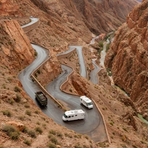
1. Dades Gorges

Tucked between the Atlas and Anti-Atlas Mountains, Dades Gorges is a surreal landscape of towering cliffs, deep canyons, and winding mountain roads in southeastern Morocco. Carved by the Dades River, the gorges stretch for nearly 300 kilometers through rocky desert terrain, Berber villages, and lush oases. It’s one of Morocco’s most breathtaking drives and a hidden gem for photographers and adventurers.
What to ExpectThe highlight of the Dades Gorges is the jaw-dropping hairpin road known as the “Serpentine Road” or “Tissadrine,” where switchbacks cling to the canyon walls. As you ascend, panoramic views unfold of the ...
Literary and Cultural Heritage
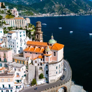
2. Amalfi Coast Drive

The Amalfi Coast Drive, also known as the SS163 or Strada Statale 163, is Italy’s most legendary coastal road. Stretching roughly 50 kilometers between Sorrento and Salerno, it winds along cliffs that plunge into the Tyrrhenian Sea, passing charming villages, lemon groves, and sky-high viewpoints. It’s not just a way to get somewhere — it’s a journey that defines the magic of southern Italy.
What to ExpectExpect a thrilling ride — literally. The narrow two-lane road is carved into the mountainside, curving tightly around rocky outcrops and offering postcard views at nearly every turn. You’ll pass ...
3. Blue Ridge Parkway
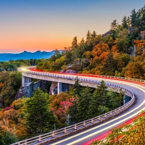
The Blue Ridge Parkway is often called “America’s Favorite Drive,” and for good reason. Connecting Shenandoah National Park in Virginia to Great Smoky Mountains National Park in North Carolina, this 469-mile route winds through some of the most beautiful and biodiverse landscapes in the eastern United States. With no billboards, stoplights, or commercial development, it offers an immersive experience in Appalachian beauty.
What to ExpectExpect sweeping views from roadside overlooks, tunnels carved through rock, and access to hundreds of hiking trails and waterfalls. The parkway climbs ridges, dips into valleys, and follows the spine of the ...
4. Cabot Trail
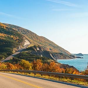
The Cabot Trail is a legendary 298-kilometer loop around the northern tip of Cape Breton Island in Nova Scotia. Known for its dramatic ocean views, winding mountain roads, and picturesque fishing villages, it’s a must-do for anyone who loves road trips and nature. Whether you're stopping for fresh seafood or hiking high above the Gulf of St. Lawrence, the Cabot Trail is pure East Coast magic.
What to ExpectExpect a full-sensory journey through Cape Breton Highlands National Park, where the road weaves between steep cliffs, dense forest, and open sea. The drive offers frequent pull-offs with ...
5. Gobi Desert Road

The Gobi Desert Road is not a road in the traditional sense, but a series of overland tracks and evolving paths that traverse one of Asia’s most formidable landscapes. Covering over 1,500 kilometers through southern Mongolia, this route winds through a world of stark beauty — camel-dotted dunes, prehistoric canyons, flame-colored cliffs, and boundless silence. It's a scenic drive in the truest adventurous spirit, perfect for 4x4 expeditions and cultural immersion.
What to ExpectTravelers can expect ever-changing scenery that shifts from rocky outcrops and gravel plains to grassy steppes and iconic sand dunes like Khongoryn Els. ...
6. Great Alpine Road
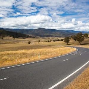
Stretching over 300 kilometers from Wangaratta in Victoria’s northeast to the coastal town of Bairnsdale, the Great Alpine Road is one of Australia’s most diverse and visually striking road trips. It winds through historic gold rush towns, mountain ranges, national parks, and wine regions, making it a top choice for travelers seeking nature, adventure, and culture — all in one epic drive.
What to ExpectExpect a landscape that shifts dramatically: from fertile farmland in the Ovens Valley to the alpine heights of Mount Hotham, then descending through eucalyptus forests and river valleys to the lakes and ...
7. Icefields Parkway
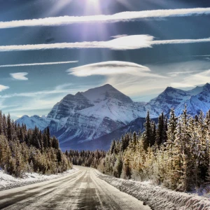
The Icefields Parkway (Highway 93) is widely considered one of the most scenic drives in the world. Stretching between Jasper and Lake Louise in Alberta, this dramatic route cuts through Banff and Jasper National Parks, offering nonstop views of majestic mountains, hanging glaciers, and glacial-blue lakes. Wildlife sightings are frequent, and every bend delivers a new postcard-worthy panorama.
What to ExpectDrivers can expect wide-open alpine views, well-maintained roads, and numerous pull-offs for photography and short hikes. Must-see highlights include Bow Lake, Peyto Lake, the Columbia Icefield, Sunwapta Falls, and Athabasca Falls. The route is lined with ...
8. Karakoram Highway
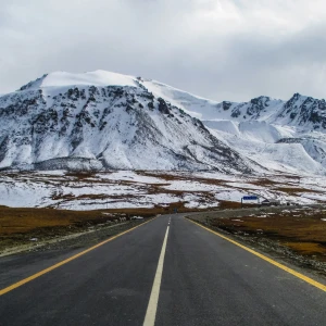
The Karakoram Highway (KKH), often called the “Eighth Wonder of the World,” is one of the most spectacular and adventurous road trips on the planet. Spanning approximately 1,300 kilometers from Hasan Abdal in Pakistan to Kashgar in China, this high-altitude route slices through some of the world’s tallest mountains, tracing ancient Silk Road paths, and passing glaciers, turquoise lakes, and traditional mountain villages.
What to ExpectTravelers can expect a visually overwhelming journey — from the green hills of Abbottabad and the mighty Indus River gorge to the jagged peaks of Gilgit-Baltistan and the serene Hunza Valley. ...
9. Lofoten Islands Road
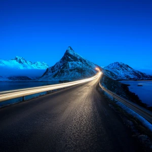
The Lofoten Islands Road, primarily made up of Norwegian County Road 815 and European Route E10, winds through Norway’s Lofoten archipelago, connecting a string of wild, mountainous islands with modern bridges and tunnels. With landscapes straight from a fantasy novel — snow-dusted peaks, turquoise bays, and red fishing cabins on stilts — this drive is a feast for the eyes and the soul.
What to ExpectExpect narrow, winding roads and jaw-dropping scenery around every bend. The route takes you through charming villages like Reine, Hamnøy, Nusfjord, and Henningsvær, all set against a backdrop of sheer granite ...
10. Milford Road
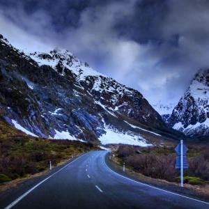
Milford Road, also known as State Highway 94, is one of the world’s most awe-inspiring scenic routes. Stretching 120 kilometers from Te Anau to Milford Sound in New Zealand’s Fiordland National Park, the drive is a dramatic showcase of glacial-carved valleys, temperate rainforest, alpine passes, and unforgettable viewpoints. It’s the only road access to Milford Sound, but the journey is as remarkable as the destination.
What to ExpectThe drive takes travelers from the gentle grasslands around Lake Te Anau into the heart of Fiordland’s rugged wilderness. Along the way, expect frequent stops at scenic pullouts such ...
11. Pacific Coast Highway (Highway 1)
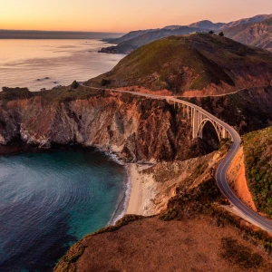
The Pacific Coast Highway, also known as California State Route 1, hugs the coast of the Golden State for over 650 miles. It’s a legendary road trip route, with unforgettable sections between San Luis Obispo and Monterey — passing through Big Sur, Carmel-by-the-Sea, Santa Barbara, and Malibu. Whether you drive a short stretch or the full distance, PCH delivers postcard-worthy views at every turn.
What to ExpectExpect winding cliffside roads with jaw-dropping coastal vistas, vintage beach towns, hidden coves, and towering redwoods. Iconic stops include Bixby Creek Bridge, McWay Falls, and Hearst Castle. There’s a constant ...
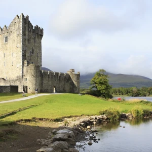
12. Ring Of Kerry

The Ring of Kerry is a breathtaking 179-kilometer (111-mile) circuit in County Kerry, Ireland. Beginning and ending in Killarney, the route travels through coastal towns, national parks, and centuries-old heritage sites. Travelers experience a striking mix of Atlantic seascapes, sheep-dotted pastures, lakeside panoramas, and moss-covered stone ruins — all within a single unforgettable day’s drive.
What to ExpectThe drive takes 3.5 to 5 hours without stops, but most visitors spread it out over a full day or more to enjoy the beauty. Expect narrow, winding roads — especially on the coastal cliffs — with frequent photo ...
13. Route 66

Stretching nearly 2,500 miles from Chicago, Illinois to Santa Monica, California, Route 66 is a pilgrimage for road trip enthusiasts and cultural history buffs alike. Once a key artery for westward migration and trade, it has transformed into a retro-infused adventure filled with neon signs, vintage diners, roadside attractions, and wide-open skies.
While the highway was officially decommissioned in 1985, much of its original route remains drivable, with lovingly restored landmarks and quirky towns preserving its charm.
What to ExpectDriving Route 66 is more about the journey than the destination. You’ll pass through 8 ...
14. Savannah Way
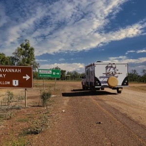
Stretching more than 3,700 kilometers (2,300+ miles) from Cairns, Queensland to Broome, Western Australia, the Savannah Way is one of Australia’s great epic drives. Traversing three states and countless ecosystems, this scenic route winds through national parks, UNESCO-listed gorges, hot springs, cattle stations, and far-flung outposts of the outback.
It’s a drive that rewards the intrepid — equal parts wild beauty, cultural depth, and road-trip freedom across the Top End of Australia.
What to ExpectThe Savannah Way passes through some of the most remote regions of Australia, including Gulf Country, the Northern Territory's Top ...
15. Silk Road

Spanning thousands of kilometers across Asia, the Middle East, and Europe, the Silk Road is not a single road, but a network of ancient trade routes that shaped the development of the world. It connected China with the Mediterranean, enabling the exchange of goods like silk, spices, tea, and ceramics — and more importantly, ideas, religions, technologies, and art.
Today, traveling along segments of the Silk Road is a bucket-list experience that weaves together desert crossings, mountain passes, ancient cities, and millennia of cultural fusion.
What to ExpectA modern Silk Road journey is a ...
16. The Outer Banks Scenic Byway
Running for approximately 138 miles (222 kilometers) along North Carolina’s coast, the Outer Banks Scenic Byway traces a string of narrow barrier islands between the Atlantic Ocean and Pamlico Sound. This winding route offers a slow-paced journey through maritime villages, shifting dunes, and wildlife-rich preserves — capturing the wild and windswept essence of the OBX.
With two ferry rides included in the route and access to places only reachable by water, this byway is as much about the journey as the destinations.
What to ExpectThe byway stretches from Whalebone Junction in Nags Head down ...
17. The Pan-American Highway
The Pan-American Highway isn’t just a drive — it’s an odyssey. This legendary route begins in Prudhoe Bay, Alaska, and ends in Ushuaia, Argentina, at the southernmost city in the world. Along the way, travelers pass through everything from arctic tundra to rainforests, volcanoes, deserts, high mountain passes, and coastal highways.
It’s a journey of extremes, adventure, and cultural immersion — offering the most comprehensive overland experience on Earth. Though not all segments are officially marked, the route is a symbol of global connection and wanderlust.
What to ExpectExpect the unexpected. The Pan-American Highway ...
18. The Road To Hana

The Road to Hana — officially Hana Highway (Route 360) — is a legendary 64-mile stretch that winds along the northeast coast of Maui, Hawaii. Far more than just a drive, it's a full-day adventure through some of the island's most lush and untouched landscapes, leading to the remote and peaceful town of Hana.
This journey offers a deep immersion into tropical Hawaii — with scenic lookouts, waterfall hikes, bamboo forests, and oceanfront stops that feel far removed from the resort scene.
What to ExpectExpect a narrow, twisting, and breathtaking drive. The road is ...
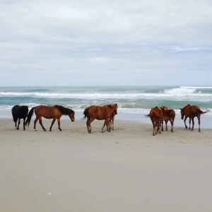
19. The Skeleton Coast Road

The Skeleton Coast Road traverses the desolate and dramatic northern shoreline of Namibia, where the scorching Namib Desert collides with the cold South Atlantic Ocean. It’s a surreal and otherworldly drive along what early sailors called “The Gates of Hell.” Today, it’s revered for its stark beauty, sense of remoteness, and glimpses of Namibia’s untamed wilderness.
Named for the countless shipwrecks and sun-bleached whale bones scattered along its coast, the route is both a historical relic and an off-grid adventure through wind-whipped sands and ancient geological formations.
What to ExpectThis drive isn’t for the ...
20. The Wild Atlantic Way
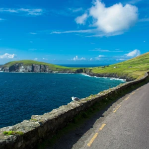
The Wild Atlantic Way is Ireland’s most epic road trip — a breathtaking coastal drive that runs from County Donegal in the north to County Cork in the south. It hugs the wild, windswept edge of the Atlantic Ocean, offering a constantly changing tapestry of sea cliffs, ancient ruins, islands, and charming villages.
This route is not about speed or efficiency — it’s about discovery. Whether you drive a single section or the entire length, each stretch brings a new panorama, a different local accent, and a deeper connection to Ireland’s rich cultural heritage and untamed natural ...